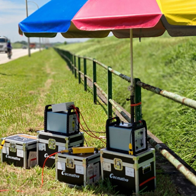
In a gold exploration project in Brazil, a geophysical survey crew used electrical resistivity and induced polarization (IP) measurements to investigate subsurface electrical contrasts that could help prioritize areas for follow-up exploration.
Resistivity and IP methods can provide an early, non-invasive source of information about how subsurface materials conduct electricity and respond to controlled electrical excitation. Their value depends on the physical-property contrast between the target and surrounding ground, target size and geometry, survey layout, electrode contact, field noise, and interpretation workflow.
Mineral exploration teams routinely face practical constraints: traditional field surveys can be slow and costly, signal quality may be affected by deep targets, high-resistance ground, poor electrode contact, or interference, and data-quality problems may only become visible after a crew leaves the site. These conditions make field quality control and a clearly defined verification plan important parts of survey design.
The GD-10 Configuration Used in the Brazil Project
The published Brazil case identifies the equipment as a GD-10 Supreme 2D+/3D+ high-density electrical exploration configuration with 24 channels and non-polarized electrodes. It should not be interpreted as a simple single-channel GD-10 measurement setup.
Geomative’s GD-10 product family uses modular and upgradeable configurations. Depending on the selected version and compatible equipment, it can support electrical survey workflows involving different electrode arrays, programmable scripts, roll-along coverage, data review, and field remeasurement.
The Brazil survey used resistivity and IP measurements to investigate electrical anomalies associated with potential mineralization and to support follow-up exploration planning. The results provided targeting information based on observed electrical and IP contrasts.
Electrical and IP anomalies do not independently confirm gold mineralization, ore grade, or mineral resources. Geological mapping, drilling, sampling, laboratory analysis, and other appropriate verification are required when exploration decisions depend on the interpretation.
Why Field Configuration Matters
A resistivity/IP survey is a complete system rather than a single instrument. Its field performance depends on the combined configuration of:
-
Host instrument and selected model version.
-
Receiving channels and measurement sequence.
-
Power supply, transmit voltage, current, and field load.
-
Switching equipment, cables, electrodes, and electrode spacing.
-
Contact resistance and grounding conditions.
-
Terrain, access, field noise, and crew capacity.
-
Data-quality review and remeasurement procedures.
The GD-10 product page describes field data-review functions that allow users to examine measurement-point information, profile and section displays, and transmit/receive waveforms. This can help a field crew identify questionable data and decide whether a point or cable section requires remeasurement before demobilization.
The exact capability of a project configuration should still be confirmed through its technical schedule and, where possible, a representative field test.
Mineral Exploration and Other Geomative Product Lines
Mineral exploration is one of several application areas for Geomative’s equipment. The company also provides tools for groundwater investigation, engineering geology, environmental monitoring, borehole logging, and subsurface monitoring.
For projects requiring different acquisition scale or survey methods, the resistivity/IP product portfolio includes GD-20, GD-12, GD-22, and GD-32 systems. These models differ in receiving-channel count, transmitter capability, waveform support, voltage range, and related accessories.
For example:
-
GD-12 has 1 receiving channel, maximum 7.2 kW transmit power, maximum 1,200 V transmit voltage, maximum 6 A transmit current, and no full-waveform acquisition.
-
GD-22 has 6 receiving channels, maximum 15 kW transmit power, maximum 1,500 V transmit voltage, maximum 10 A transmit current, and full-waveform acquisition.
-
GD-32 has 12 receiving channels, maximum 15 kW transmit power, maximum 1,500 V transmit voltage, maximum 10 A transmit current, and full-waveform acquisition.
The models list different technical configurations, so channel count, power, waveform capability, accessories, and survey productivity should be confirmed by the exact selected model rather than inferred from the GD product family as a whole.
TEM as a Separate Mineral Exploration Method
Geomative also provides transient electromagnetic systems under the GT product line. In a published project at the Beishan lead-zinc mine in Hechi, Guangxi, GT-30 TEM surveys were used for underground mineral and groundwater investigation.
The project interpretation combined TEM data with geological information and known spatial relationships between ore veins and water-prone zones. The published case reports subsequent exposure verification of the interpreted results.
TEM and resistivity/IP methods respond to different physical conditions. TEM may help investigate conductive contrasts and geological structures, while resistivity/IP methods investigate electrical and chargeability-related contrasts. Neither method alone confirms an ore body, mineral resource, aquifer, or groundwater condition.
DIGspace and Data Workflow
Geophysical survey data is often interpreted together with geological mapping, drilling records, borehole logs, and other project information. DIGspace is Geomative’s geoscience platform for multi-source data management, desktop analysis, web collaboration, visualization, anomaly interpretation, and related processing workflows.
Current platform information describes support for electrical survey, GPR, drilling-log, GIS, CAD, BIM, and other data types, together with ERT inversion and integrated two-dimensional and three-dimensional presentation.
The GD-10 product page separately describes Geomative Studio as supporting exported txt, Excel, dat, and urf files. Buyers should verify which software product, version, device interface, and method module applies to their intended data-processing and export workflow.
Three-dimensional visualization, three-dimensional volume construction, and full three-dimensional inversion are different capabilities. They should be specified separately when defining project requirements or acceptance criteria.
About Shenzhen Geomative Technology Co., Ltd.
Shenzhen Geomative Technology Co., Ltd., operating under the Geomative brand, is a Shenzhen-based provider of geophysical instruments and digital subsurface solutions established in 2011.
The company states that it is a National High-Tech Enterprise in China and that its products serve customers in more than 50 countries worldwide. Its portfolio includes DC resistivity and IP instruments, TEM systems, magnetometers, hydrogeological logging equipment, monitoring systems, and the DIGspace geoscience platform.
These company facts provide background on the supplier. Equipment selection should still be based on the project’s target properties, field conditions, required survey geometry, configuration, software workflow, technical support, and verification plan.
For mining operators and geologists, the practical takeaway from the Brazil case is that resistivity, IP, and TEM surveys can help prioritize areas for further exploration when the target properties and survey design are suitable. They do not replace geological confirmation; they help determine where drilling, sampling, mapping, exposure, or other verification work is warranted.
https://www.geomative.com/
Geomative Co., Ltd.
About Author